River bathymetry and velocity mapping specialists WaterCube LLC recently completed a three-day field survey of the Silver River in Florida. The goal was to develop a detailed view of the river characteristics needed for mathematical modeling. The survey area is highly vegetated with dense sub-aquatic plant coverage and substantial tree canopy presenting problems both for satellite positioning and depth determination using echo sounders.
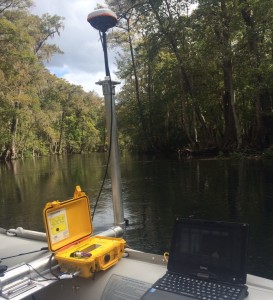
Acoustic Doppler current profilers (ADCPs) were used for flow measurements, but this instrument was incapable of providing accurate bathymetry in most of the survey area. Previous attempts to collect good quality soundings with basic single beam echo sounders had not been particularly successful. WaterCube used the CEE HydroSystems™ 200 kHz CEESCOPE™ echo sounder to accurately map the river bed despite the tricky conditions underwater. Using a 20 Hz ping rate and collecting a high definition water column echo envelope with the single beam sonar, WaterCube were able to remove spurious results from debris, logs, floating material and aquatic vegetation. Position data from the Hemisphere AtlasLink GNSS receiver was fed directly into the CEESCOPE™ unit, and visualized in real time by Eye4Software Hydromagic. The hydrographic data were post processed in HYPACK® and exported to WaterCube data processing and visualization software to provide a complete view of the Digital Elevation Model combined with flow data previously collected. WaterCube then visualizes, manages and compares results over time within their Cubeit visualization software. In addition, Cubeit allows for modelers to compare and overlay real measured data with their mathematical model to calibrate and improve accuracy for future predictive behavior.
John Sloat, WaterCube CTO said “The new Hemisphere GNSS receiver performed great despite the canopy, allowing us to cover most of the survey area and still have an acceptable satellite position accuracy; using the CEESCOPE™ allowed us to present bathymetry data we could trust”. Combining this data with flow characteristics and additional water quality data allows WaterCube to be a data aggregator and bring a complete solution to our customers using the latest technology innovations in field data collection today.
WaterCube LLC offers hydrologic and hydrographic data processing, field survey consultancy and visualization software for managing inland water environments.