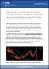
What is an Echogram – Full Water Column Echo Envelope?
The CEESCOPE™ and CEE-ECHO™ output and record a high definition echogram, which is advantageous for determining accurate bathymetry. In addition to providing a complete record of the survey raw data, the echogram allows detailed post processing of recorded soundings to edit inaccurate or spurious depth signals, impossible to achieve with “black box” echo sounders.
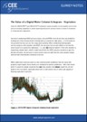
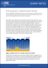
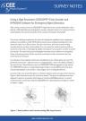
The Value of a Digital Echogram – Surveying over Sub Aquatic Vegetation
The CEESCOPE™ and CEE-ECHO™ output a high definition echogram, a view of the sonar echo envelope from the entire water column. That is not just a depth sounding value from each ping. The echogram output offers substantial benefits for surveys conducted in areas with sub-aquatic vegetation.
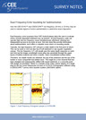
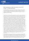
The Value of a Digital Echogram – Surveying over a Soft Bottom
A dual frequency echo sounder is usually used for surveys where the bottom may be poorly defined, or when sediment resuspension is occurring, such as during dredging. In addition, collecting a digital echogram using the CEESCOPE™ or CEE ECHO™ helps provide a detailed view of the bottom and sub-bottom to allow proper identification of the hard and soft bottom surfaces.
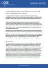
Dual Frequency Echo Sounders for Sedimentation
A dual frequency echo sounder may indicate where sediment deposition is occurring and can show spatial distribution of areas of recent sedimentation. HYPACK® software has some excellent visualization tools to make use of this echo sounder output.

Understanding Transducer Beam Angles and Data Artifacts
The effect of the transducer beam angle on single beam hydrographic data may be quite significant in some survey scenarios, such as when vertical structures or steep slopes may be included in the survey area. Understanding the beam footprint of various transducers is useful in product selection and the limitations of wider beam transducers should be recognized.

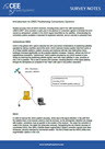
How the CEE-USV™ Uses Exact Time-Stamped Data to Prevent Telemetry Errors
In order to maintain exceptional data quality with telemetered data when using the CEE-USV™ unmanned survey boat, the CEESCOPE LITE™ echo sounder applies a precise time tag to all data recorded internally and output to the shore over the radio. The results of a field test using the latest HYPACK® driver are shown.

Introduction to the Hydrographic Survey Workflow When Using the CEE-USV™
To provide some insight into the general method of using the CEE-USV™ for hydrographic surveying, particularly for those not familiar with hydrographic surveying procedures, a simplified workflow is presented to outline the basic steps taken from project setup to data export.

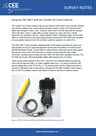
Using Bluetooth to Send or Receive Data for the CEE ECHO™ or CEESCOPE™
The CEESCOPE™ and CEE ECHO™ have a built-in Bluetooth radio that may be used to receive incoming GNSS position data from an external receiver. The Bluetooth radio may also be used to output real time data to a PC or GNSS data collector when used in a simplified acquistion mode. Follow the steps in this guide to successfully establish a reliable Bluetooth connection.

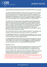
Driver Selection in HYPACK for the CEESCOPE™ and CEE ECHO™ - HYPACK 2021 Q3 AND LATER ONLY!
HYPACK 2021 Q3 streamlined the management of the CEE time stamps used in data acquisition. The suggested driver setup for 2021 Q3 and later releases requires only the standard GPS-NMEA0183 driver. The custom CEE-GPS driver is STILL REQUIRED if additional devices such as side scan are used simultaneously. It remains critical to properly configure the HYPACK drivers for the appropriate release version to avoid data timing issues.
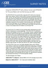
Driver Selection in HYPACK for the CEESCOPE™ and CEE ECHO™ - HYPACK 2021 Q2 AND EARLIER ONLY!
HYPACK offers two methods to acquire data when using CEE echo sounders with the proprietary time-stamped output format. When using the echo sounder and GNSS alone, as in most SBES surveys, the special CEE time stamps may be used for maximum timing precision. If using ancillary devices without time stamped data such as side scan, an alternative driver setup is required.

Technical Review – Driver Selection in HYPACK for the CEESCOPE™ and CEE ECHO™ - ALL HYPACK RELEASES
This technical document describes in detail the criteria for appropriate driver selection in HYPACK when using the CEE ECHO™ or CEESCOPE™ with or without additional instruments (e.g. side scan sonar). This may be used as a reference guide for setup options with HYPACK. This guide relates to the use of the custom CEE-GPS driver that must be used if additional devices such as side scan are used.
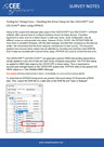
Testing HYPACK Driver Setup for the CEESCOPE™ and CEE ECHO™
This guide may be used to check a test RAW file recorded in HYPACK to make sure the driver setup is correct. The time stamps of the recorded RAW data lines are inspected to check that the time stamps are written correctly and no time offsets are present. Time offsets might be very small - from a few milliseconds - to very large - several hours.

Understanding and Selecting Blanking Modes for the CEESCOPE™ and CEE ECHO™
Echo sounders with the appropriate 2020 year firmware are able to operate in three different blanking modes, useful for shallow water surveys – particularly when using the CEE-USV™. The ADAPTIVE, MINDEPTH, and MANUAL blanking modes are explained and illustrated to allow the user to make an informed choice for each survey.
Using the CEESCOPE™ with NTRIP Network RTK Corrections through HYPACK or Hydromagic
The CEESCOPE™ is able to receive network RTK corrections from an acquisition device connected to the internet. Owing to its built-in network connectivity, NTRIP RTCM data may be passed to the CEESCOPE’s integrated GNSS receiver through the same Ethernet LAN cable or WiFi connection as the survey data is transmitted. With no additional hardware or cables, this represents a simple and effective method to acquire RTK precise survey data.

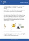
Using Trimble CenterPoint RTX with the CEESCOPE™ 9250
The CEESCOPE™ with BD9250 and BD990 integrated GNSS receivers are able to receive Trimble's precise 2.5cm RTX single-antenna L-Band corrections. Users of the CEESCOPE™ 9250 should be aware of Trimble's L2/L5 frequency band selection requirement as both frequencies cannot be operated simultaneously. The CEESCOPE™ 9250 CenterPoint RTX position data accuracy was tested and compared to network RTK. Two-hour observation RTX tests confirmed the superiority of the L5 frequency (default) option versus the L2 frequency.
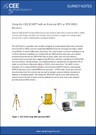
Using the CEESCOPE-R™ with WiFi and SBG Systems Ellipse2-E Motion Reference Unit for Jet Ski Surveys
The CEESCOPE-R™ is a unique echo sounder system that adds WiFi connectivity and a convenient Motion Reference Unit / Inertial Navigation System interface. With few cables and a highly streamlined setup, the system is ideal for surveying in challenging environments such as the surf zone on a personal watercraft (Jet Ski).

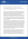
Using the CEE JET 1600 with SBG Ellipse Motion Sensor and Hydromagic
The CEE JET 1600™ hydrographic survey system for personal watercraft (PWC) surveying includes a WiFi module for wireless connection to a tablet screen for navigation and a simplified motion sensor interface for attitude error corrections. Survey data may be recorded inside the CEESCOPE-R™ echo sounder including motion data from the SBG Systems Ellipse MRU. RTK corrections may be received by network using the WiFi link to a waterproof tablet PC running the Hydromagic NTRIP plugin. This presents an integrated package with maximum ease of use, critical for operation in PWC survey environments).
Connecting to Network RTK using the CEESCOPE Trimble BD990 / 9250 Internal NTRIP Client via the Ubiquiti UMR-Industrial Router
The CEESCOPE’s Trimble BD990 and BD9250 GNSS receivers can directly receive network / NTRIP corrections, eliminating the need for a connected survey PC to provide a corrections stream. Using the Ubiquiti UMR-industrial router, conveniently powered by the CEESCOPE-R (dual-Ethernet option) through a powered (POE) Ethernet RJ45 cable offers a robust connection to the server and enables the user to collect network RTK data recorded on the CEESCOPE’s internal memory without a connected PC.

Using RAW GNSS Data Recorded on the CEESCOPE™ for Post Processed Precise Positioning in HYPACK®
The CEESCOPE® records raw GNSS data on its internal memory which can be extracted and used in post processing to recompute a precise positioning dataset after corrections using a reference station. The new position data may be inserted into HYPACK® in place of the original uncorrected data. This feature allows RTK-quality data to be collected in the absence of a local base station radio telemetry link or cell phone VRS network.

Importing CEESCOPE™ and CEE ECHO™ Data into HYPACK and Hydromagic Projects
The CEESCOPE™ records raw GNSS data on its internal memory or a connected USB flash drive which can be extracted and used in post processing to recompute a more accurate position solution. These data may be easily imported into a HYPACK or Hydromagic project for editing, however it is important to follow the appropriate procedure to ensure the desired project geodesy and measurement units are properly set up in the final data file.
Using the CEESCOPE™ and CEE ECHO™ in RTK Mode on a Local Grid
For land surveyors, the process used in hydrography to collect the coordinate position and elevation data underwater might be unfamiliar. However, using an RTK-enabled system it is easy to collect data that will fit seamlessly into separately collected land survey datasets using the same RTK GNSS receivers / base station.
Using an External GNSS Receiver with the CEE ECHO™ – Introduction
The CEE ECHO™ is designed to take in NMEA0183 format position from a GNSS / GPS receiver and merge the position data with echo sounder data simultaneously being recorded. The combined data stream is output to an acquisition software package.

Using an External GNSS Receiver with the CEE ECHO™ – Detailed Setup Guide
There are several benefits from passing GNSS data to the CEE ECHO™ instead of directly to the acquisition PC. The position and depth data may be viewed on the CEE ECHO™ LCD, data may be recorded internally, and precise time stamps may be applied to the data for a low latency solution.

Considerations for Using the CEESCOPE-RTK Echo Sounder with an RTK Base Station
In order to receive RTK corrections from a base station, the data format and radio transmission format must be matched. Sometimes there is some confusion about pairing GNSS equipment from different manufacturers, with the concern that the base station must match the rover receiver. However as long as the formats are properly selected there should be few concerns about GNSS brand used.
Surveying Around Bridges Using the CEESCOPE™ and CEE ECHO™
The CEESCOPE™ and CEE ECHO™ record time-stamped data in the absence of a valid GNSS / GPS fix. This feature can be used in post processing to correct poor or unusable bathymetry data collected in areas where the sky view is restricted. Using interpolation, approximate positions can be assigned to the sounding depths collected during the GPS loss.
Using the CEE LINE™ with the Trimble TSC3 Data Collector and Trimble Access or Geometius BathySurvey App
The CEE LINE™ is a “plug and play” solution for the Trimble TSC3 data collector. With no Bluetooth or batteries to worry about, the echo sounder is powered and controlled entirely by the data collector. The quick-start setup guide explains the process for using the CEE LINE™ within the Trimble Access environment.
Using the CEE LINE™ with the Trimble TSC5 Data Collector and Trimble Access via Bluetooth
The CEE LINE™ may be used with the Android-based TSC5 data collector however the use of an external Bluetooth module is required. The self-contained Bluetooth module allows the CEE-LINE™ data to be received for acquisition as the TSC5 in the absence of a compatible USB interface. The TSC5 may still be used to power the CEE-LINE™.
Using the CEE LINE™ with the Trimble TSC7 Data Collector and Trimble Access
The Trimble TSC7 is an ideal partner for the CEE LINE™ echo sounder, as it can utilize the single power / data USB connection and also run the CEE LINE CONNECT software for the echo sounder configuration.

Using the CEE LINE™ with Carlson SurvCE Acquisition Software
The CEE LINE™ echo sounder may be used as a peripheral hardware input while GNSS surveying using Carlson software. Connection of the echo sounder to a GNSS data collector using SurvCE represents a simple and effective method to conduct basic hydrographic surveys

Hydrographic Echo Sounder Concepts and Using the CEE LINE™ with a GNSS Data Collector
The CEE LINE™ echo sounder is often used with GNSS data collectors in a simplified hydrographic acquisition setup, with operators unfamiliar with hydrographic surveying processes. This overview explains some key concepts to understand before starting out.
Single Beam Bathymetry Using the "Land Survey" versus "Hydrographic Survey" Approaches
The CEE LINE™ echo sounder and a GNSS data collector represents a relatively straightforward approach to hydrographic projects. The pros and cons of using this survey method versus a conventional professional hydrographic approach based on the CEE ECHO™ or CEESCOPE™ echo sounders with dedicated acquisition software is outlined in this detailed article. This overview will be useful to inform equipment selection decision making.

Using the CEESCOPE™ and CEE ECHO™ with HYPACK® to Accurately Map Sub Aquatic Vegetation Extents
To determine the extent of sub aquatic vegetation coverage and the plant height, the echogram feature of advanced CEE echo sounders may be used in combination with HYPACK® editing and visualization tools to provide a simple and very effective habitat mapping option. An example Eelgrass survey in San Diego Bay, USA demonstrates the process.
All Echo Sounders are not Created Equal – Ping Rates Matter
The echo sounder ping rate is a key feature that should be considered when selecting a single beam sonar system for bathymetry. Low ping rates (<5 Hz) cannot provide adequate coverage in challenging environments, and the advantages of high ping rates partly lie in data processing after the survey is completed.
How the CEESCOPE™ was used to Find a Missing Structure
An unusual challenge was presented: use the dual frequency CEESCOPE™ to locate a 30m structure that had vanished – presumably sunk. The data processing in HYPACK® described in this article illustrates some general concepts relating to single beam echo sounder data and transducer properties.
CEE VIEWS – Why we do not make Echo Sounders with Paper Chart Recorders
Despite there occasionally still being a requirement for paper records supporting single beam hydrographic surveys, we choose not to offer any echo sounders that have this feature. Besides focusing more on portable units where paper is of no value, here are our thoughts on why we believe the paper chart to be entirely unnecessary.
CEE VIEWS – Why Single Beam Echo Sounders Continue to have a Place Alongside Multibeam
For many surveys, multibeam echo sounders have become the instrument of choice. However this is far from true for many types of hydrographic survey where a single beam echo sounder, possibly combined with a side scan sonar, offers the most attractive solution.

CEE VIEWS – Industrial Water Hydrographic Surveying
CEE HydroSystems’ equipment is used around the world for industrial water surveying – mine tailings ponds, process water reservoirs, paper mill effluent ponds, municipal waste water, oil field frac pits, and chemical plants. Some of the main topics involved in single beam hydrographic surveying in the industrial environment are discussed in this article. If you have survey projects in industrial water READ THIS ARTICLE before you get started.
CUSTOMER PROJECT – Using a Dual Frequency CEE ECHO and a USV to Evaluate Mine Tailings Deposition
In addition to providing valuable water volume data for site water balance models and tailings storage facility (TSF) operations, using advanced echo sounder techniques may also provide insight into tailings deposition pattern and compaction processes. This paper as presented by Newfields LLC at the Tailings and Mine Waste 2016 conference in Keystone, CO, USA describes an unmanned survey vehicle approach to tailings dam bathymetry.

CUSTOMER PROJECT – Using the CEESCOPE™ with Hydromagic and RosePoint ECS Navigation Software
In order to provide navigation surveys for US inland river transportation, Eye4Software Hydromagic may be used to generate surveys that can be imported into RosePoint ECS as a chart overlay. This article outlines the required software and hardware setup to allow the two software packages to simultaneously access survey data from the CEESCOPE™ echo sounder, and describes the process to import survey data from Hydromagic into RosePoint ECS.
General Hydrographic Survey Procedures

Basic Hydrographic Surveying Concepts
For surveyors not familiar with hydrographic processes and equipment, some of the commonly asked questions are answered.
RTK Tide Concepts for Precise Vertical Elevation Correction in HYPACK
Using GNSS height measurements has become the new standard for hydrographic surveying in order to correct elevation changes during the survey. The principle behind “RTK Tides” is simple however confusion may arise about exactly what is going on. This summary may help with some of the basic concepts behind RTK Tides.
The Benefits of Time-Stamped Echo Sounder Data
Routing GNSS / GPS data directly to the echo sounder allows the precise time-tagging of the sounding position, offering reduced latency and a more resilient and exact survey dataset.

How to Survey Using Local Grid Coordinates in Hydromagic
It is possible to collect data in any local / construction / mine grid using Hydromagic or HYPACK with any CEE echo sounder. The process to set up a local grid simply requires a coordinate pair in the local grid and a standard grid, and the grid parameters are calculated automatically. Despite what is often thought, having a connection to a base station on site configured in the local grid is NOT a requirement to undertake a survey using local grid geodesy.
Positioning / GNSS Topics
Introduction to GNSS Positioning Corrections
Selecting GNSS equipment is highly dependent on the source of corrections used to achieve the desired accuracy. This GNSS topic can be a confusing jargon-filled space especially for people unfamiliar with the technology. This overview details the various sources of GNSS corrections available, with specific reference to the GNSS-enabled CEESCOPE™ echo sounder.
Using the CEESCOPE™ and CEE ECHO™ with Emlid Reach Bluetooth GNSS Receivers
The popular low-cost Emlid Reach GNSS receivers may be easily paired with the CEESCOPE™ and CEE ECHO™ using a Bluetooth link. Unlike more complex survey GNSS, that can sometimes present a challenge for Bluetooth communications, the Reach devices are simple to configure, and interface easily and reliably with third-party equipment such as the CEE echo sounders. If you have an Emlid Reach GNSS, follow this setup guide to receive its GNSS data directly to the echo sounder to eliminate the need for a separate PC connection and gain data quality benefits.
Precise Point Positioning (PPP) Overview and Options for the CEESCOPE™
Single antenna PPP operation is useful for some survey situations, when other precision corrections are unavailable. The CEESCOPE™ echo sounder can receive various PPP services; Hemisphere Atlas, NovAtel / Hexagon TerraStar or Trimble RTX. This document explains how the services work and an overview of how the CEESCOPE™ is operated when setting up for PPP.

RTK Corrections Formats and Troubleshooting
RTK-equipped CEESCOPE™ echo sounders are used with network / Virtual Reference Station (VRS) or UHF base station corrections. In both cases, misunderstandings about the setup and available corrections data formats can lead to reduced GNSS performance or the inability to achieve proper RTK Fixed position at all. Learn about the key points to consider when setting up a base station link to a CEESCOPE™.